

CFAES experts know the challenges Ohio growers and producers face due to a variety of reasons. A Rapid Response Team was created to quickly address current events and offer the best science-based recommendations to protect livestock, crops, and farm operations due to weather impacts, tariffs, commodity prices, and extreme events.
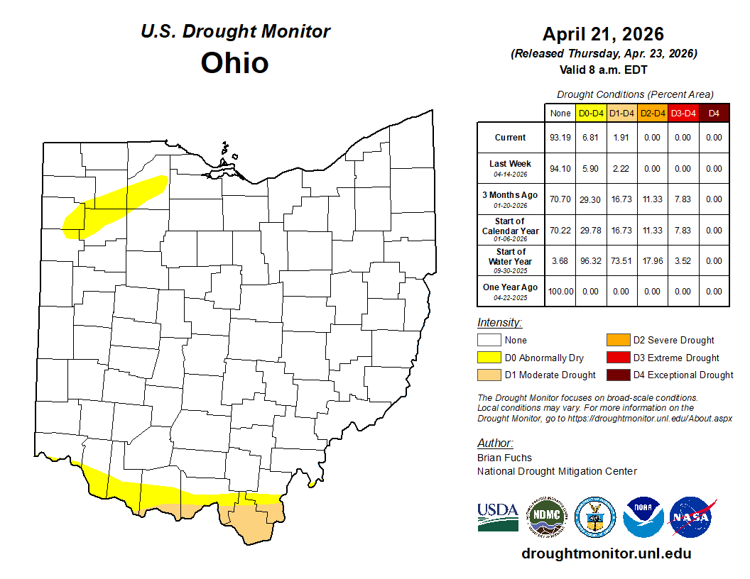
April 24, 2026: For the first time Since August 26, 2025 (239 days), northwest Ohio is drought free according to the U.S. Drought Monitor. Since March 1, 2026, much of northwest Ohio has received 7.5-15 inches of precipitation. Many of the hydrological indicators (river levels, soil moisture, farm ponds and reservoir levels) that strongly suggested drought conditions throughout the fall and winter have recovered. However, drought focus has now shifted to southern Ohio where precipitation has been lacking.
Since spring began (March 1), areas near the Ohio River from east of Cincinnati to Portsmouth have only picked up 4-6 inches of rain (50-85% of normal). While this drier weather across southern Ohio has allowed for accelerated planting conditions, warmer and windier than normal conditions have soil moisture values in the plant and root zones decreasing rapidly. In response, we now have about 2% of the state (southern portions of Brown, Adams, Scioto, Lawrence and Gallia Counties) in D1 – moderate drought.
An active pattern is in the forecast with multiple opportunities for rainfall and severe weather over the next seven days (April 24 – 30). Totals across much of Ohio could reach 1 to 2 inches, which could help slow drought advancement across southern Ohio. Public reports of conditions are always welcome and can be made by visiting go.osu.ed/drought_cmor. Our next update will be provided by May 8, 2026.
Note: The U.S. Drought Monitor only includes precipitation for the week through 8 am Tuesday mornings.
Updates provided by:
Aaron Wilson, Ag Weather and Climate Field Specialist
Stephanie Karhoff, Agronomic Systems Field Specialist
Jason Hartschuh, Dairy Management and Precision Livestock Field Specialist
Garth Ruff, Beef Cattle and Livestock Marketing Field Specialist
Dave Marrison, Farm Management Field Specialists and Interim Director of the Farm Financial Management and Policy Institute
Logan Minter, Specialty Crops Field Specialist
Jim Downs, Forestry Field Specialist
Vinayak Shedekar, Agricultural Water Management
Jeff Hattey, Soil Management State Specialist
Chris Zoller, Interim Assistant Director, Extension ANR
Rob Hamilton, Division of Soil and Water Program Manager, Ohio Department of Agriculture
 |
 |
 |
For more current drought data, visit drought.gov.
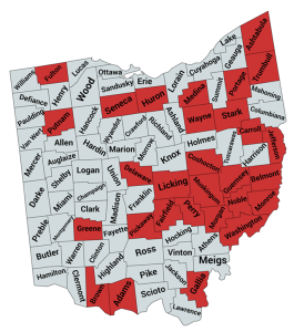
Climate rankings for August will be released by NOAA on Tuesday September 9, 2025, which will likely show that August 2025 was one of the driest August’s on record since 1895. Despite some precipitation falling across the Buckeye State over the last seven days (mostly less than 1 inch), much of Ohio is running well below normal for the last 30 days (Figure 1). Last week’s U.S. Drought Monitor shows an increase in D0-abnormally dry and D1-moderate drought conditions to 83% and 29%, respectively.
Read more.
“If you can’t change the situation, you adapt.” That’s a familiar mindset for many in agriculture, and it’s especially true in 2025. This growing season has brought another round of extreme weather across Ohio and the Midwest, making forage production unpredictable and challenging.
Learn more
- Rapid drought intensification
- Manure application to parched soil
- Drought, an early harvest, and fall herbicide applications
- Dry conditions in corn - implications and recommendations
- Forage nitrate toxicity a major concern as drought worsens
- Debby surprises but drought intensifies across southeast
- Worsening drought conditions in southern Ohio
- Weather extremes abound
- Weed management in hot, dry conditions
- Wheat harvest and double crop considerations for 2024
- New ANR fact sheet summarizing corn response to long-term weather patterns
- Beating the heat on farms
Drainage
Managing Controlled Drainage Structures in Spring and Fall
Drought and Drainage
Video: Battle for the Belt
Video: Corn Response to Drought
The Ohio Department of Agriculture has an Ohio Hay Directory for producers trying to sell or buy hay during the drought updated for 2025. If you have hay to sell, add your information here.
Ohio State University Extension BEEF Team
Winter Feeding Options for Beef Cows - program schedule in October 2024
- Addressing Feed & Forage Shortages
- Manure Application to Parched Soil
- Ohio Beef Cattle Letter
- Feeding Storm-Damaged Soybean Grain to Cattle
- Drought 2024: Winter Feeding Options for Beef Cows
- Drought to Frost: Feeding Safe Forages
- "Fog Fever" a Fall Pasture Problem
- Making Decisions During Drought
- Using Drought Stressed Soybeans For Hay or Silage
- Managing Forage to Finish 2024
- The Summer Grazing Plan
- Managing Heat Stress in Beef Animals
- Considerations for Pasture Risk Management Decisions
- Pasture Management Strategies During Dry Conditions
- Drought Management (Ohio Beef Cattle Letter archives)
- Mow Pastures or Not
- OSU Extension BEEF Team videos
Agricultural operations in Ohio have been significantly impacted by recent drought. The U.S. Department of Agriculture (USDA) Farm Service Agency (FSA) has programs available to help farmers and livestock producers recover from these adverse weather events. Impacted producers should contact their local USDA FSA Service Center to report their losses and learn more about program options available to assist in their recovery from crop, land, infrastructure, and livestock losses and damages.
- Worksheet to Prepare for Your First Visit with USDA
- Establishing a Customer Record and Farm Record
- CRP Haying and Grazing (2025)
- Disaster Assistance At A Glance
- Disaster Assistance: ELAP - Livestock Assistance
- Farm-Raised Fish (2025)
- Honeybees (2025)
- Livestock (2025)
- Disaster Assistance: Emergency Disaster Designation and Declaration Process
- Disaster Assistance: Emergency Conservation Program (ECP)
- Disaster Assistance: Emergency Loan Program (updated)
- Disaster Assistance: LFP - Livestock Forage Disaster Program (2025)
- Disaster Assistance: Livestock Indemnity Program (2025)
- Disaster Assistance: Noninsured Crop Disaster Assistance Program (2025)
- Disaster Assistance: Tree Assistance Program
- Disaster Assistance: What is the U.S. Drought Monitor?
Turf Team Times - also available on YouTube, Apple Podcasts and Spotify
Updates provided by:
Aaron Wilson, Ag Weather and Climate Field Specialist
Jim Downs, Forestry Field Specialist
Jason Hartschuh, Dairy Management and Precision Livestock Field Specialist
Jeff Hattey, Soil Management State Specialist
Stephanie Karhoff, Agronomic Systems Field Specialist
Dave Marrison, Farm Management Field Specialist and Interim Director of the Farm Financial Management and Policy Institute
Logan Minter, Specialty Crops Field Specialist
Garth Ruff, Beef Cattle and Livestock Marketing Field Specialist
Vinayak Shedekar, Agricultural Water Management
Chris Zoller, Interim Assistant Director, Extension Agriculture and Natural Resources
